
Russian River
These additional “regional scenario” subset of maps illustrate the differences in flood extents and depths under conditions of an open or closed inlet at the Russian River mouth near Jenner, California. The results were computed with CoSMoS version 2.0 (same as that used for the region between Point Reyes and Point Arena) using the same 100-year coastal storm event as in previous simulations (deepwater significant wave height = 10.93 m, peak wave period = 17 s, incident peak wave direction = 260° and storm surge and sea level anomalies = 0.40 m), but with a higher fluvial discharge rate that approaches the flood stage in Guerneville (9.75 m or 32 feet, USGS National Water Information System). These forcing conditions were all simulated for present day sea level and for five half-meter sea level rise (SLR) scenarios (0.50 m, 1.0 m, 1.5 m, 2.0 m, and 5.0 m). In all, a total of 12 flood maps are provided.
Closed inlet scenarios were developed by raising the bathymetry across the inlet to an elevation exceeding the SLR plus maximum tide level. The inlet was assumed non-erodible, but overwash was allowed. Areas that appear wet across the closed inlet are because modeled extreme water levels overwashed the the inlet bar.
The figures below provide examples of changes made to the digital elevation model (Figure 1) and simulated time-series of water levels within the estuary (Figure 2) for the open and closed inlet conditions. Both figures are for the 1 m SLR scenario.
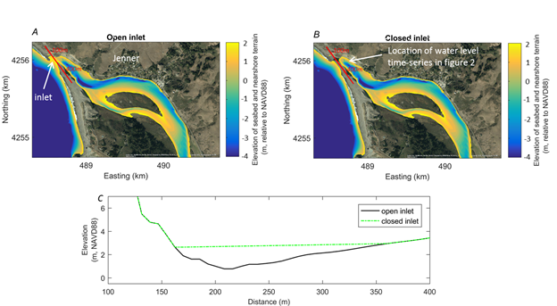
Figure 1. Maps showing elevations of the seabed and nearshore terrain for the (A) open and (B) closed inlets. (C) Cross-section along the red line in A and B showing the differences in the open and closed inlet elevations
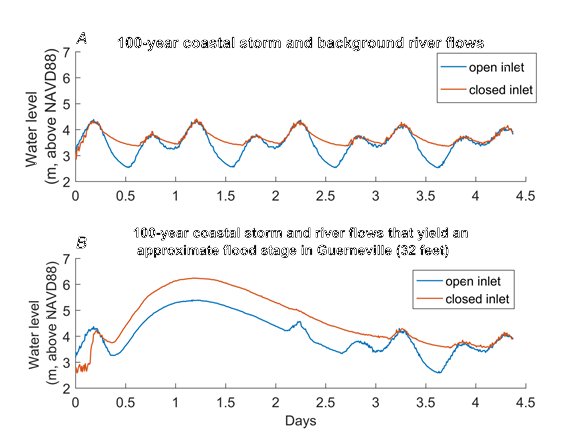
Figure 2. Plots showing numerically computed time-series of water levels immediately landward of the Russian River mouth near Jenner for the 1 meter sea-level rise scenario. (A) Water levels for the 100-year coastal storm and background river flows. (B) The same 100-year coastal storm but with river flows that yield a flood stage of ~32 feet in Guerneville.
Marshes on the Margins - Southern California Tidal Wetlands
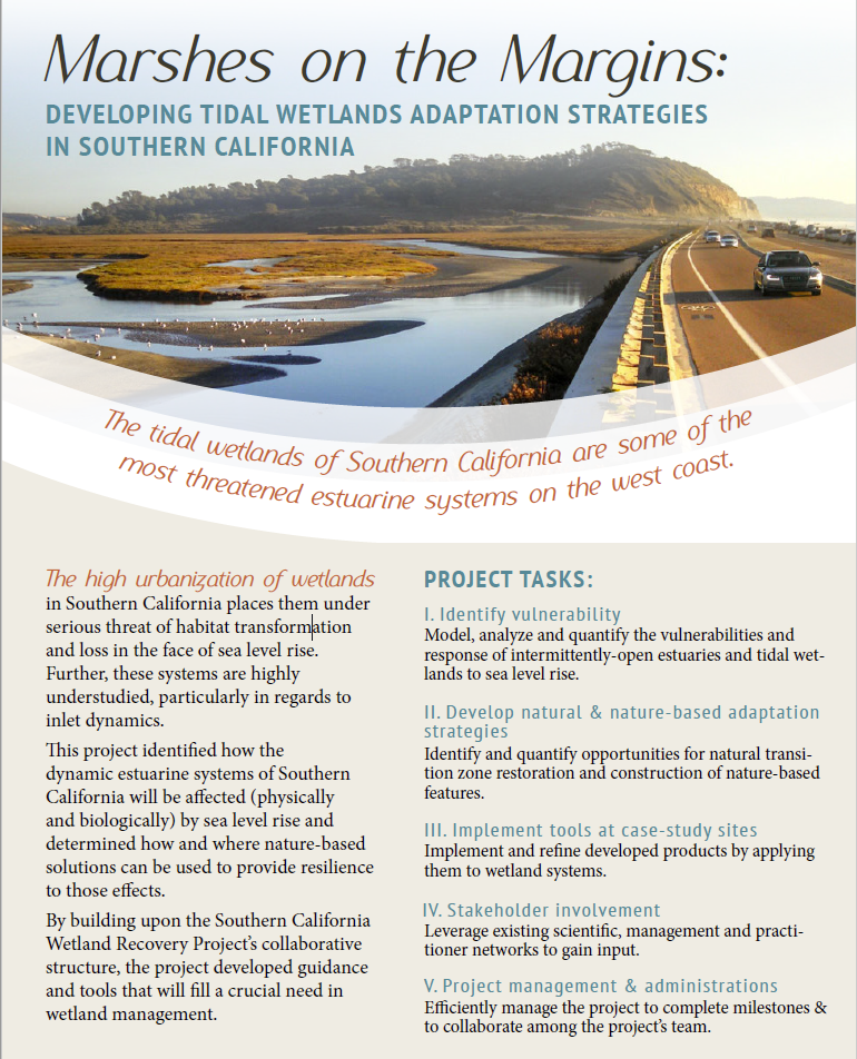
The tidal wetlands of Southern California are some of the most threatened estuarine systems on the west coast. The high urbanization of wetlands in Southern California places them under serious threat of habitat change and loss in the face of sea level rise. Further, these systems are highly understudied, particularly in regards to inlet dynamics.
The Marshes on the Margins project identified how the dynamic estuarine systems of Southern California will be affected (physically and biologically) by sea level rise and determined how and where nature-based solutions can be used to provide resilience to those effects. It built upon and supported the Southern California Wetland Recovery Project to develop guidance and tools for wetland management.
One task of this effort was to model, analyze and quantify the vulnerabilities and response of intermittently-open estuaries and tidal wetlands to sea level rise. Additional “mouth closed” scenarios were run for three case study sites in Southern California: Goleta Slough (Santa Barbara County), Los Peñasquitos Lagoon, and the Tijuana River Estuary (San Diego County).
Results were computed with CoSMoS version 3.0, used for the Southern California bight, and include outputs for flood depth, maximum wave height, and current velocity for the following scenarios:
- Mouth “open” and mouth “closed” scenarios
- Sea level rise of 0cm (baseline), 50, 100, 150, 200, and 500cm
- Coastal storm scenarios of 0 (average daily conditions), Annual, 20-year, and 100-year return intervals
As of August 1, 2021: PRELIMINARY DATA for Los Peñasquitos Lagoon are available to view in the Hazard Map. These data are subject to change.
Additional products from the project are available at: scwrp.databasin.org.