How fast are seas rising?
Understand the latest sea level rise projections for California and guidance for planning
What is CoSMoS?
Learn more about the USGS Coastal Storm Modeling System
What hazard information is available?
Understand what output products from the CoSMoS model are available to view in OCOF and how to access GIS data downloads
Sea Level Rise
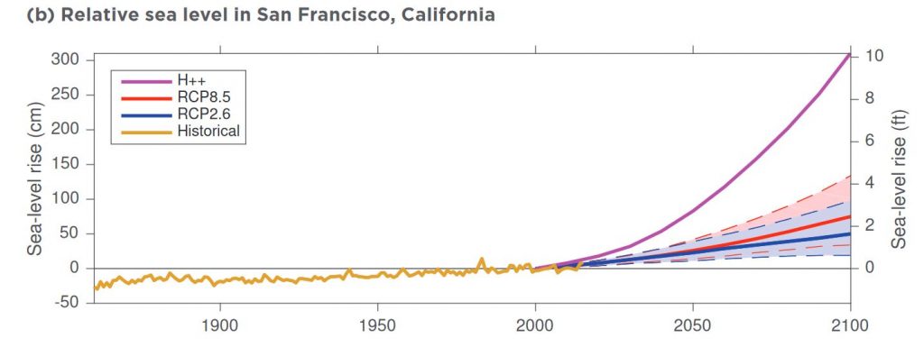
One of the clearest signs of human-caused climate change is the accelerating rate of rising seas. Greenhouse gas emissions from human activity result in oceans that expand as they warm (known as thermal expansion) and as they receive additional water from melting glaciers and ice sheets. Coastal communities are already experiencing more frequent and more extreme flooding and erosion than ever before.
The latest projections being used for planning in California (OPC 2017) indicate that seas could rise by 3 to 10 feet by 2100, depending on how well we can curb our greenhouse gas emissions and how quickly ice is lost from the Antarctic ice sheet. The latest planning guidance from the State of California was updated in 2018 by the Ocean Protection Council and California Natural Resources Agency. The Guidance suggests that communities plan for a range of sea level rise scenarios, depending on the potential lifespan, consequences, and risk tolerance for a given action. The California Coastal Commission has also updated their guidance for addressing rising seas in Local Coastal Programs and Coastal Development Permits.
The suite of scenarios available in the Our Coast, Our Future tool span the range of potential sea level and storm conditions from near- to long-term, giving users a clear picture of potential exposure to flooding and erosion hazards under a given scenario. Projections are available for multiple storm scenarios (daily conditions, annual storm, 20-year- and 100-year-return intervals) under a suite of sea level rise increments from 0-9.8 feet (0-3 meters), and an extreme 16.4ft (5m) scenario. Follow the guidance recommended below to determine which scenarios to use for your specific purposes. You can also check out the Case Studies to see what scenarios others have used for a variety of planning purposes.
Latest Science Projections
OPC Rising Seas 2017
The latest SLR projections being used by most California agencies for planning purposes.
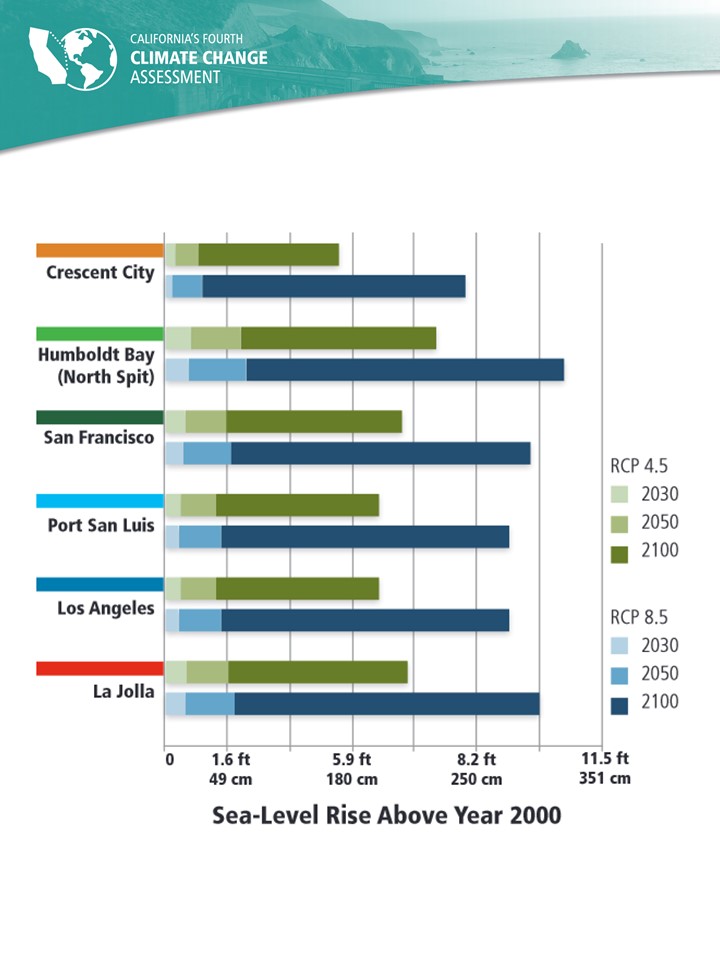
California's 4th Climate Assessment 2018
For research purposes, includes quantification of the potential for rapid loss of the Antarctic ice sheet.
Latest Planning Guidance
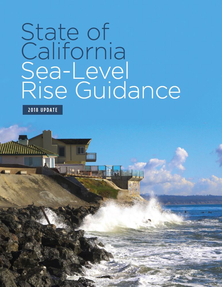
OPC State SLR Planning Guidance 2018
The latest guidance from the State of California for planning for sea level rise, based on the 2017 Rising Seas report.
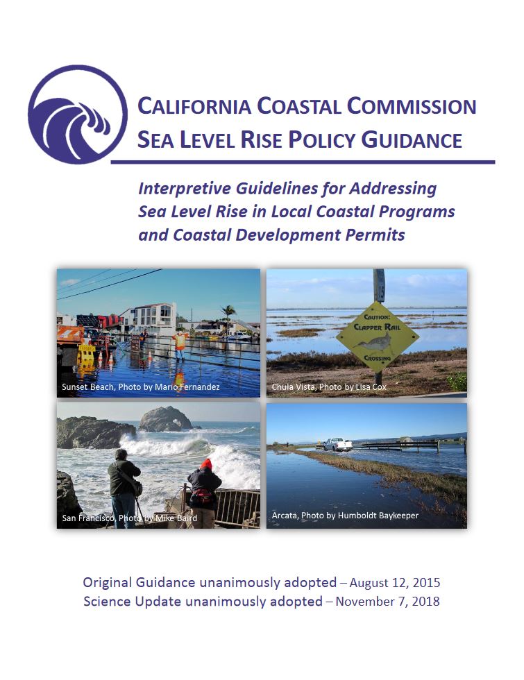
Coastal Commission SLR Policy Guidance 2018
The California Coastal Commission's updated planning guidance for addressing SLR in Local Coastal Programs and Coastal Development Permits.
About the Coastal Storm Modeling System
The Coastal Storm Modeling System (CoSMoS) is a modeling approach developed by the U.S. Geological Survey that projects coastal flooding and shoreline change (sandy beach change and cliff retreat) due to both sea level rise and coastal storms driven by climate change. CoSMoS was designed to understand the present-day and future vulnerability of the coast in support of federal and state climate change guidance, local planning, and emergency response.
What makes CoSMoS unique?
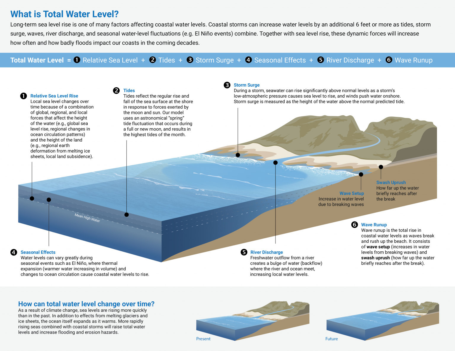
To ensure that communities do not underestimate their risk, the CoSMoS model includes all factors that contribute to changes in coastal water levels. Long-term sea level rise is only one of many factors affecting coastal water levels (see details about Total Water Level below). Coastal storms can increase water levels along the West Coast of the United States by an additional 6 feet or more as tides, storm surge, waves, river discharge, and seasonal water level fluctuations (e.g. El Niño events) combine. Together with sea level rise, these dynamic forces will increase how often and how badly floods impact our coasts in the coming decades.
Frequently Asked Questions
The FAQ here is for the San Francisco Bay Area (CoSMoS v2.x), which currently covers the inner San Francisco Bay and outer coast from Golden Gate to Point Arena.
This FAQ was developed for Southern California (CoSMoS v3.0), but is generally applicable for all the new (v3.x) outer coast modeling.
Selected Technical References
Below are some of the key references that cover the CoSMoS suite of models. A complete list of references can be found at www.usgs.gov/cosmos
Most recent overview
Barnard, P.L., Erikson, L.H., Foxgrover, A.C., Finzi Hart, J.A., Limber, P., O’Neill, A.C., van Ormondt, M., Vitousek, S., Wood, N., Hayden, M.K., and Jones, J.M., 2019. Dynamic flood modeling essential to assess the coastal impacts of climate change. Scientific Reports, Volume 9, Article #4309, 13 pp., http://dx.doi.org/10.1038/s41598-019-40742-z
Southern California
O’Neill, A.C.; Erikson, L.H.; Barnard, P.L.; Limber, P.W.; Vitousek, S.; Warrick, J.A.; Foxgrover, A.C.; Lovering, J. Projected 21st Century Coastal Flooding in the Southern California Bight. Part 1: Development of the Third Generation CoSMoS Model. J. Mar. Sci. Eng. https://doi.org/10.3390/jmse6020059
Erikson, L., Barnard, P., O’Neill, A., Wood, N., Jones, J., Finzi Hart, J., Vitousek, S., Limber, P., Hayden, M., Fitzgibbon, M., Lovering, J., and Foxgrover, A. 2018. Projected 21st Century Coastal Flooding in the Southern California Bight. Part 2: Tools for Assessing Climate Change-Driven Coastal Hazards and Socio-Economic Impacts. Journal of Marine Science and Engineering, 6(3), 76. https://doi.org/10.3390/jmse6030076
Erikson, L.H., Barnard, P.L., O’Neill, A., Limber, P., Vitousek, S., Finzi-Hart, J., Hayden, M., Jones, J., Wood, N., Fitzgibbon, M., Foxgrover, A., and Lovering, J., US Geological Survey, 2018. Assessing and Communicating the Impacts of Climate Change on the Southern California Coast. California’s Fourth Climate Change Assessment, California Natural Resources Agency. Publication number: CNRA-CCC4A-2018-013.
San Francisco Bay
Barnard, Patrick L., van Ormondt, Maarten, Erikson, Li H., Eshleman, Jodi, Hapke, Cheryl, Ruggiero, Peter, Adams, Peter N., and Foxgrover, Amy C., 2014, Development of the Coastal Storm Modeling System (CoSMoS) for predicting the impact of storms on high-energy, active-margin coasts: Natural Hazards, v. 74, i. 2, pp. 1095-1125. https://doi.org/10.1007/s11069-014-1236-y
Cliff Retreat
Limber, P.W., Barnard, P.L., Vitousek, S., and L.H. Erikson. 2018. A model ensemble for projecting multidecadal coastal cliff retreat during the 21st century. Journal of Geophysical Research: Earth Surface, 123, 1566–1589. https://doi.org/10.102/2017JF004401
Shoreline Change
Vitousek, S., P. L. Barnard, P. Limber, L. Erikson, and B. Cole (2017), A model integrating longshore and cross-shore processes for predicting long-term shoreline response to climate change. J. Geophys. Res. Earth Surf., 122, 782–806, doi:10.1002/2016JF004065
Groundwater
Befus, K.M., Barnard, P.L., Hoover, D.J., Finzi Hart, J.A., and C.I. Voss. 2020. Increasing threat of coastal groundwater hazards from sea-level rise in California. Nat. Clim. Chang. 10, 946–952. https://doi.org/10.1038/s41558-020-0874-1
Available Products
Erosion
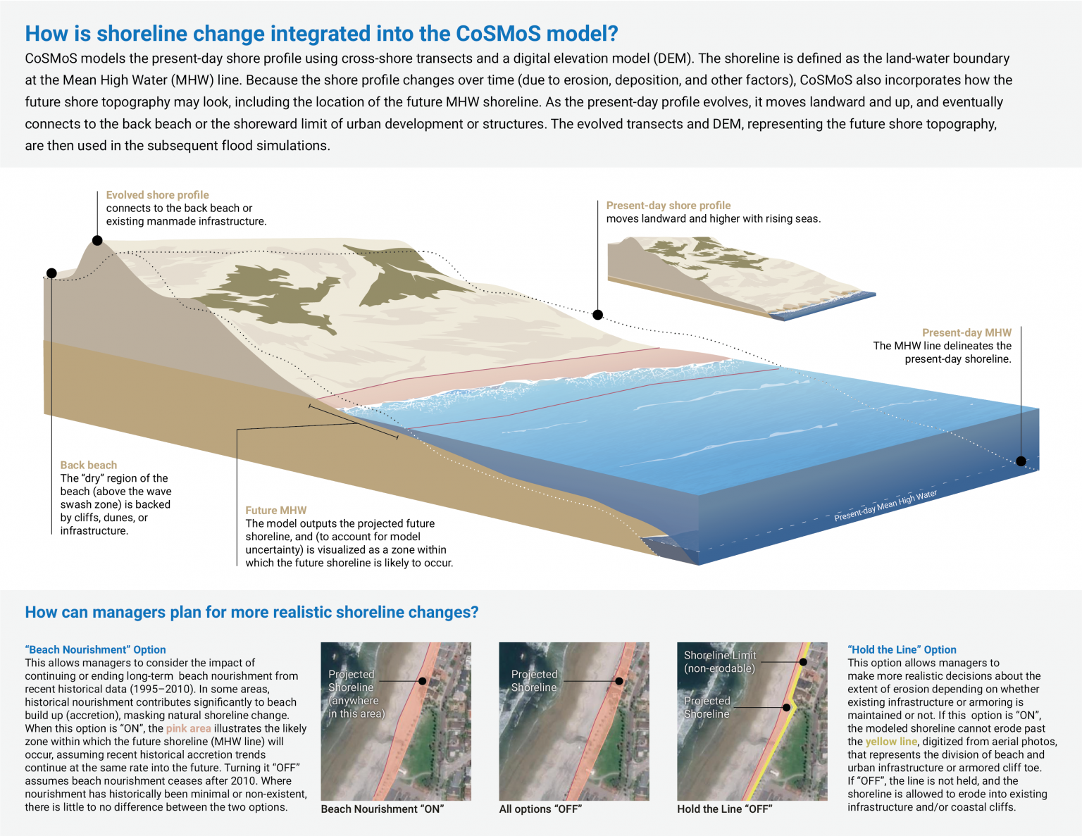
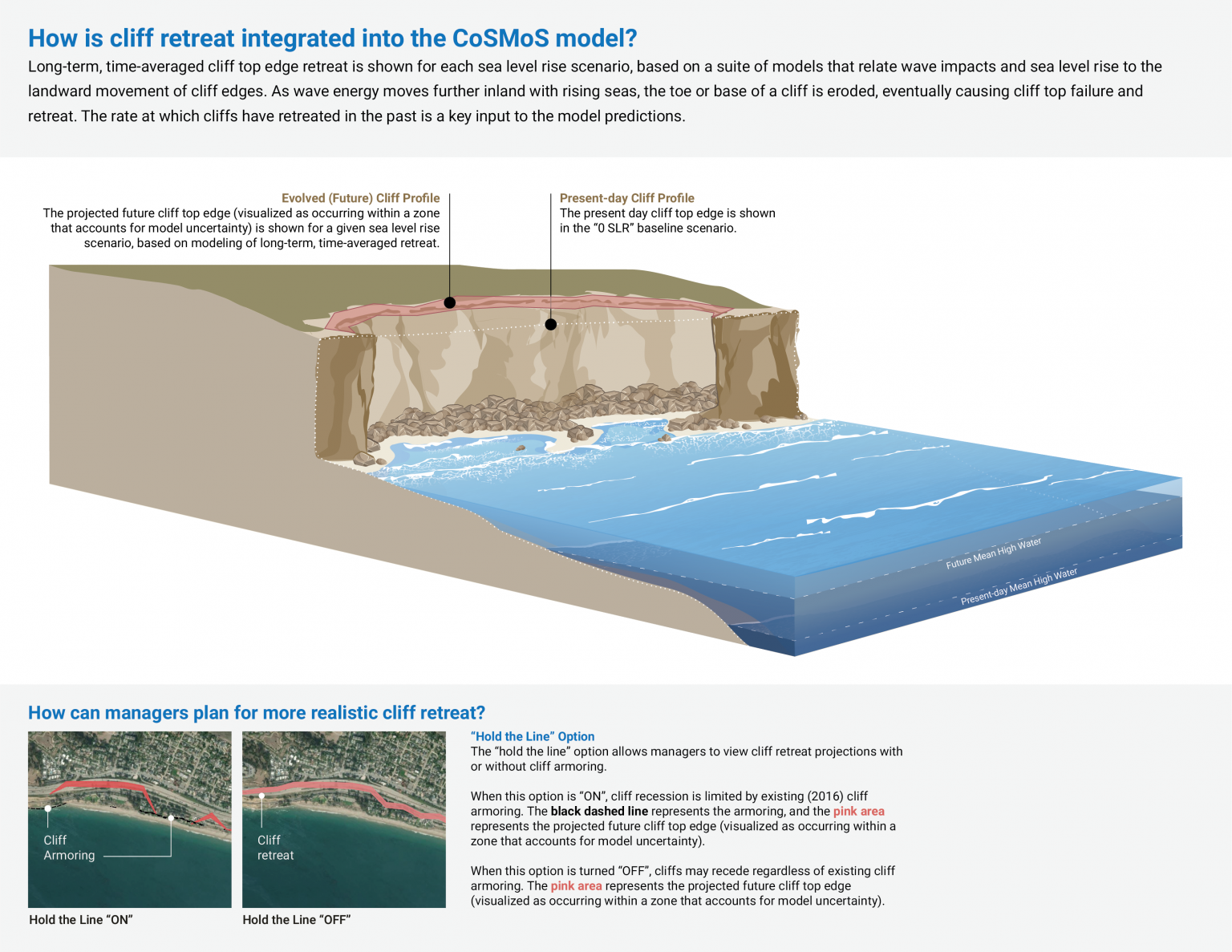
Projected long-term topographic changes from shoreline position and cliff/bluff retreat are the first components to be modeled for a suite of sea level rise increments from 0-3 meters (0 – 9.8 feet), and an extreme 5m (16.4 ft) scenario.
The outputs visualized in the Our Coast, Our Future viewer are limited to the “hazard zone” projected to encompass the future mean high water (MHW) shoreline and future cliff top edge. Additional products are available on USGS ScienceBase.
Flooding
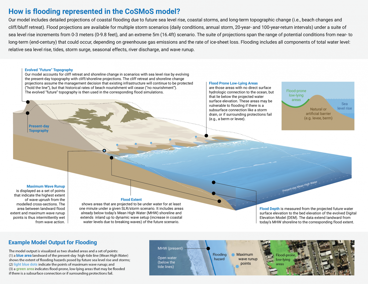
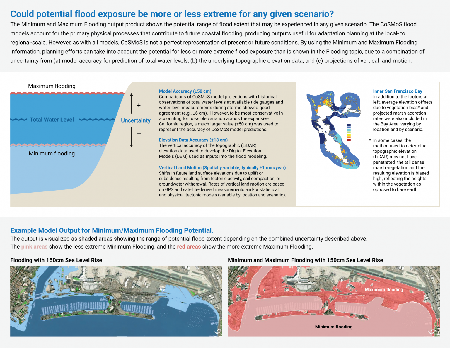
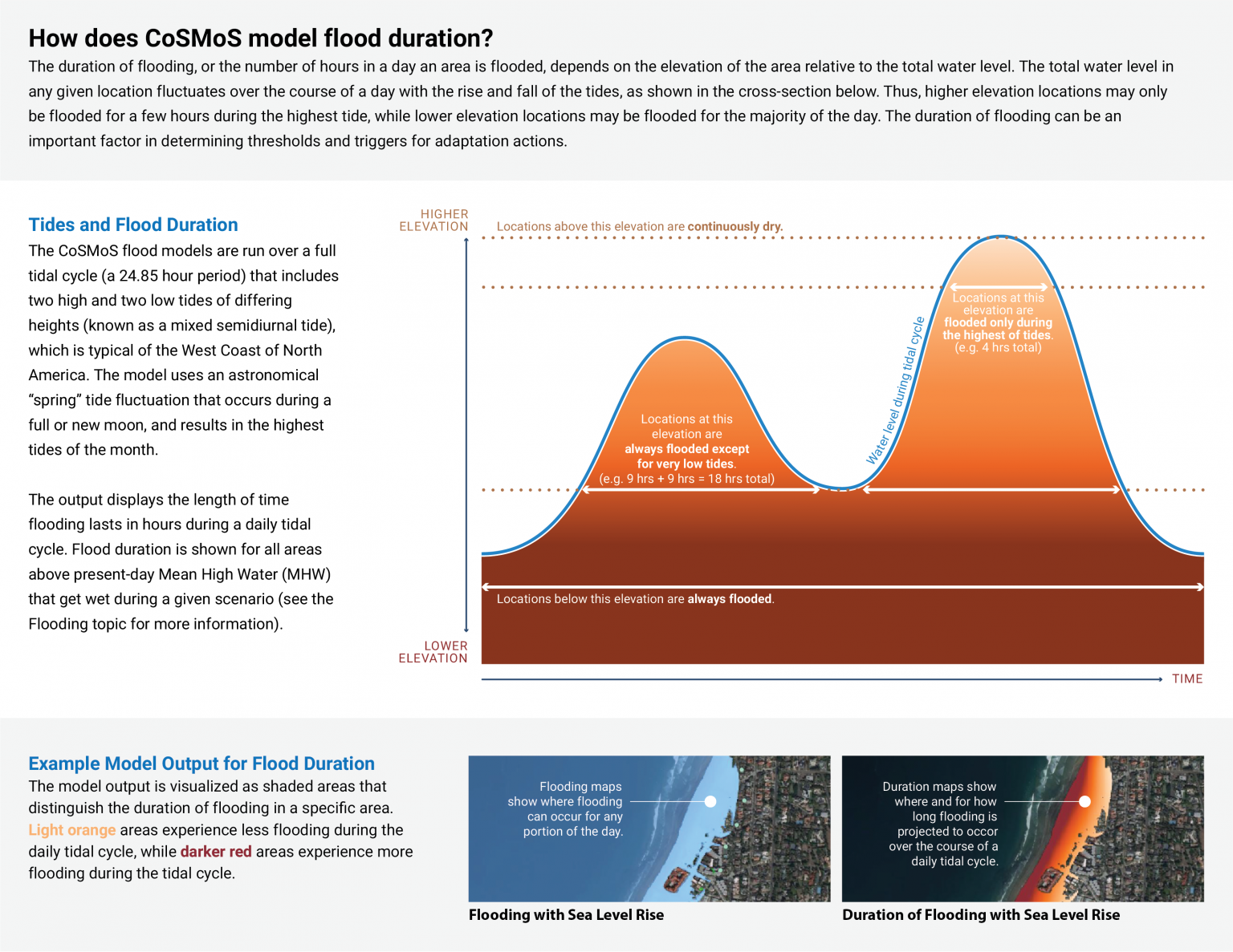
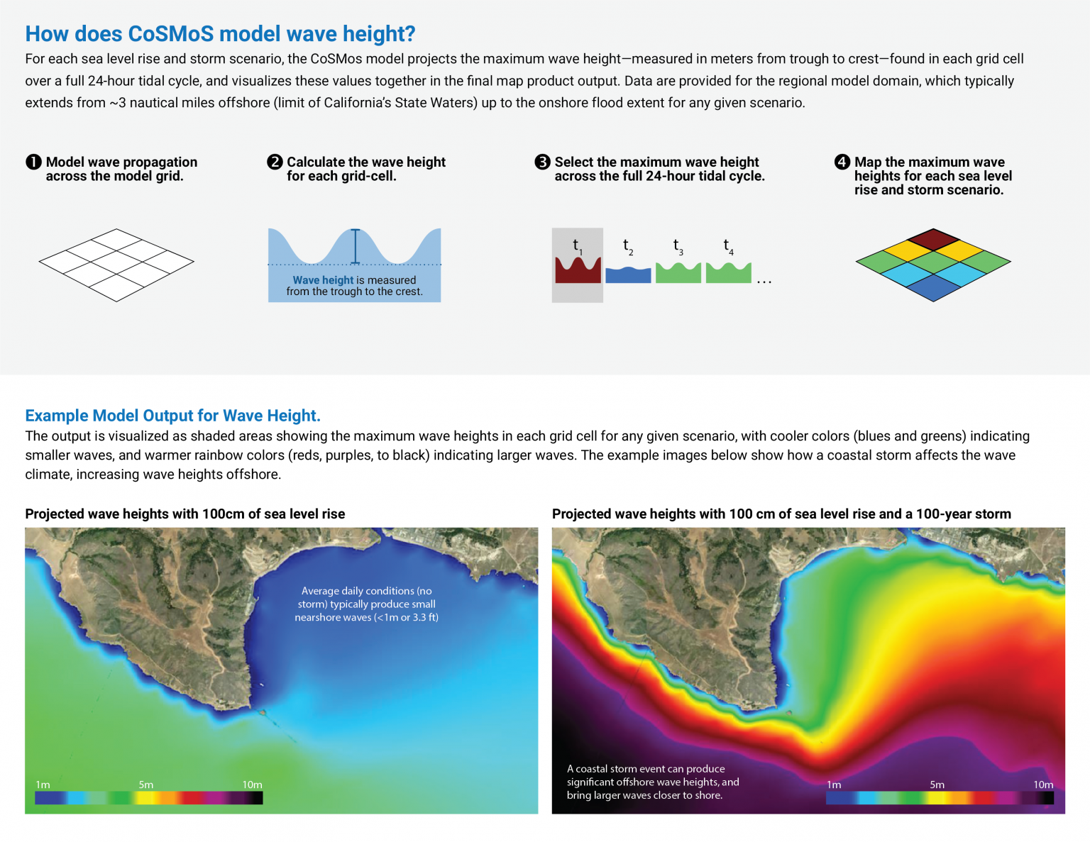
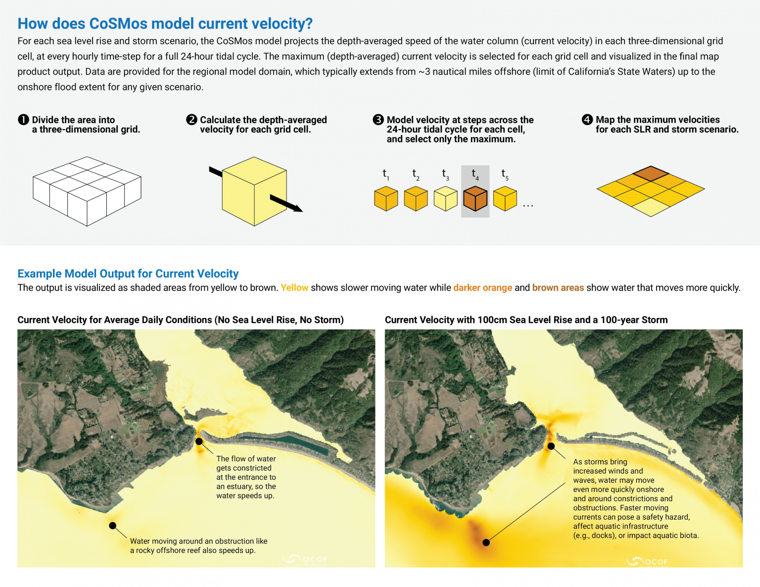
The model includes detailed projections of coastal flooding due to future sea level rise, coastal storms, and long-term topographic change (i.e., beach changes and cliff/bluff retreat). Flood projections are available for multiple storm scenarios (daily conditions, annual storm, 20-year- and 100-year-return intervals) under a suite of sea level rise increments from 0-3 meters (0-9.8 feet), and an extreme 5m (16.4ft) scenario.
Groundwater (*NEW)
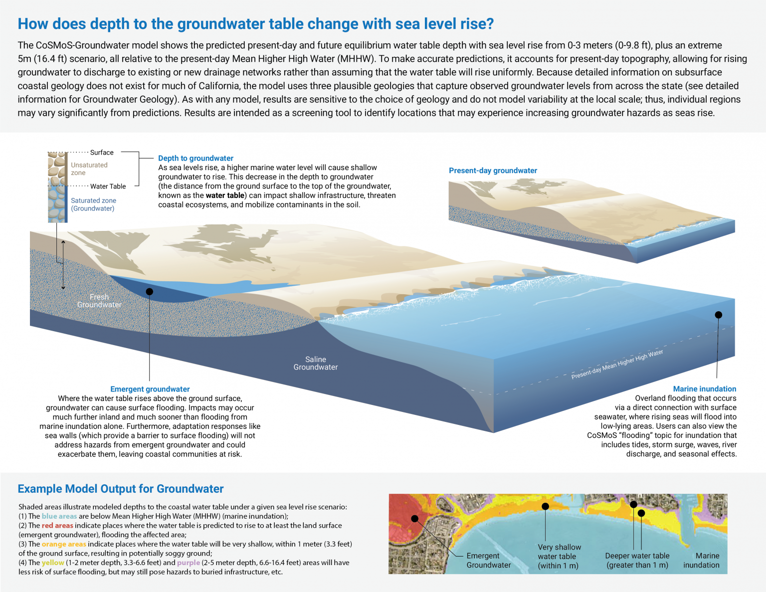
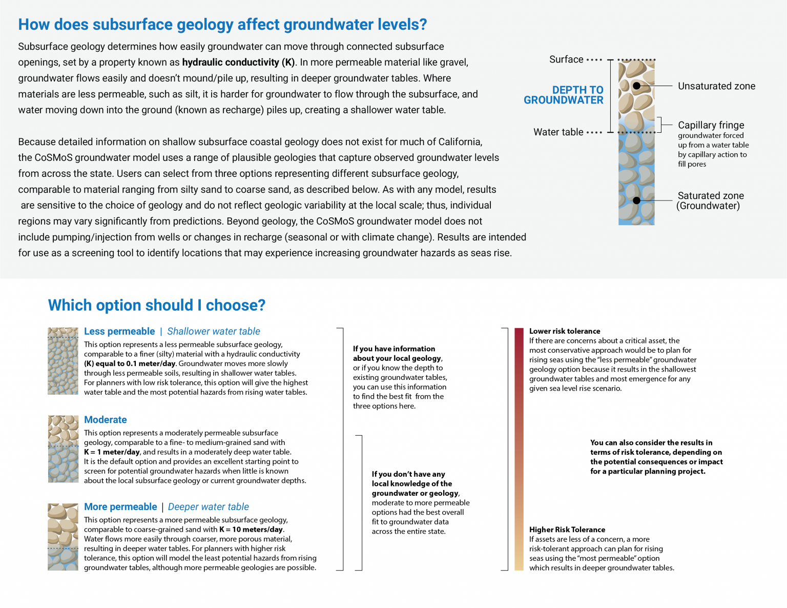
The CoSMoS-Groundwater model shows the predicted present-day and future equilibrium water table depth with sea level rise from 0-3 meters (0-9.8 feet), plus an extreme 5m (16.4ft) scenario, all relative to the present-day Mean Higher High Water (MHHW) tidal datum.
The outputs visualized in the Our Coast, Our Future viewer are limited to the “projected groundwater emergence and shoaling…” product showing groundwater tables binned into depth classes for the MHHW marine boundary condition. Additional products are available on USGS ScienceBase.
For more details on erosion products:
For more details on flooding products:
For more details on groundwater products:
How to Download GIS Data
Instructions for how to access downloadable geospatial data for all CoSMoS products, including those visualized in the OCOF hazard map.
- Download instructions
- Links for additional CoSMoS data not visualized in OCOF
- Links to metadata
- What CoSMoS versions and scenarios are currently available for download
