History and Partnerships

Our Coast, Our Future is a partnership between Point Blue Conservation Science and the USGS Pacific Coastal and Marine Science Center, and was collaboratively developed with many local, state, and federal partners as it expanded across California. As of January 2026, it provides sea level rise and storm scenarios for the entire coast of California, including San Francisco Bay and the Channel Islands.
It was originally launched in 2011 and focused on the San Francisco Bay and outer coast area (Half Moon Bay to Bodega Head). The USGS led the modeling, Point Blue Conservation Science developed the online platform and supported end-user engagement, and staff from the Greater Farallones National Marine Sanctuary, Corovai, the San Francisco Bay National Estuarine Research Reserve, and NOAA’s Office for Coastal Management led a technical assistance and outreach effort to co-develop the tool with end-users.
An expansion north to Point Arena was completed in 2015, in partnership with NOAA Fisheries, the Sonoma County Water Agency, and NOAA’s Office for Coastal Management. The work here supported NOAA’s Russian River Habitat Blueprint, as well as coastal adaptation planning and estuary management in the region.
The Southern California bight was completed in 2018 as part of the State of California’s Fourth Climate Change Assessment, in partnership with USC Sea Grant, the Tijuana River National Estuarine Research Reserve, the San Diego Regional Climate Collaborative, and the San Diego Climate Alliance.
The Central Coast region was completed in 2020, with funding from the Ocean Protection Council.
In 2021, statewide groundwater hazard data (Befus et al. 2020) were included to help planners understand and plan for how rising seas will affect the coastal groundwater table in their area. We also made significant upgrades to the OCOF platform and re-launched the current site in August 2021.
Statewide shoreline change hazards were updated using new satellite-derived shoreline methodology (Vitousek et al. 2023). This update replaced existing shoreline change data on the OCOF platform in 2024.
Flood modeling for the North Coast region (Humboldt, Del Norte, and Mendocino counties) was completed in 2025, with funding support from the Ocean Protection Council. With the addition of Mendocino County to OCOF in January 2026, flood hazard products are now available for the entire state of California.

Getting Started
If you are brand new to OCOF, we suggest you look over these resources to get a quick introduction to the project and how OCOF can benefit your work.

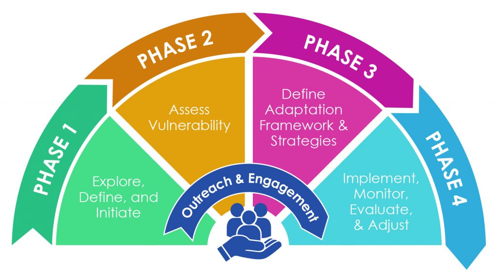
OCOF is a decision-support tool that can be used during a climate change adaptation planning process, and was designed specifically for use in the “Assessment” stage (Phase 2 of example at left from California APG 2.0). A typical adaptation planning process begins with an initial information gathering stage, during which the organization leading the process identifies the public infrastructure, private property, people, habitats, and other community assets that are at risk of sea level rise impacts. During the “Planning” phase, different adaptation strategies are assessed to see which are the most effective, and these strategies are then incorporated into plans like General Plans, Local Coastal Programs, Habitat Management Plans, etc. Finally, a plan is formally adopted and the adaptation strategies described in the plan can be implemented, evaluated, and modified to meet evolving needs. An adaptation planning process can take from several months to several years, depending on the size and complexity of the situation that the plan is addressing. OCOF can help this process by providing the science needed to understand and evaluate how sea level rise could impact your community.
If you are unfamiliar with OCOF, this two-page introduction and video tutorials [COMING SOON] will provide an overview of the project and the tools available on this website.
A webinar of the launch of the updated OCOF site was held on August 10. Recording and more info here.
The OCOF platform was developed in collaboration with the decision-making audience that it was intended to support, including land use planners, coastal resource managers, restoration managers, hazard mitigation planners, floodplain managers, emergency services managers, stormwater managers, municipal engineers, municipal leaders, zoning and permitting officials, public works officials, and conservation organizations.
OCOF and the underlying USGS CoSMoS data have been used for a variety of climate vulnerability and adaptation activities. Case Studies highlight some of the ways in which the tool and data have been used, including:
- Sea level rise vulnerability assessments and coastal adaptation planning
- Municipal plans, such as General Plans, Climate Action Plans and Local Coastal Programs
- Infrastructure (levees, roads, etc) vulnerability assessments and maintenance plans
- Hazard Mitigation Plans
- Species protection plans, such as Habitat Conservation Plans
- Restoration plans
- Natural resource management plans
- Public engagement and communication
How to Cite
For screenshots or data downloaded from the Our Coast, Our Future web platform, we suggest the following citations:
Get Help and Provide Feedback
You can contact us at ocof@pointblue.org with any questions or for technical assistance.
